
ROOTS & DUST
Stand on the low ground east of Turlock, or drive the long straight stretch of Highway 99 between Modesto and Merced, and the logic of the place begins to reveal itself. The land opens into an immense plain, flat enough to feel almost deliberate, framed by mountains on both sides and stretching north and south beyond the horizon. At dusk, the Sierra catches the last light while the basin floor settles into shadow. It is one of California’s defining landscapes, yet also one of its least understood.
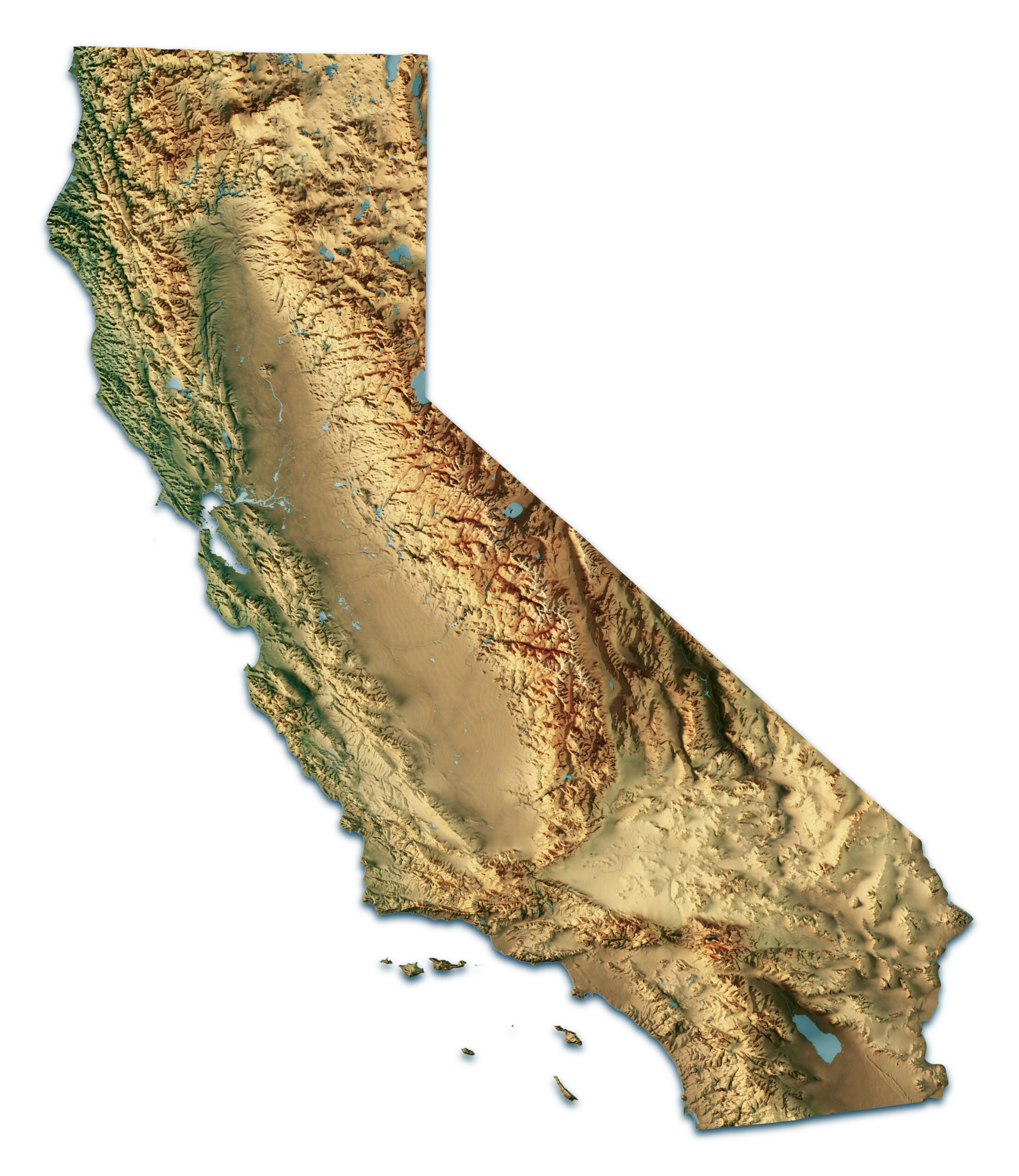
The Central Valley — also called the Great Valley, and in its southern reaches the San Joaquin Valley — is roughly 450 miles long and 40 to 60 miles wide. It feeds cities, anchors industries, carries freight, stores water, and supports millions of lives. Yet for all its importance, it is still too often treated as background: the space between the coast and the mountains, the practical middle of a state more famous for beaches, cliffs, redwoods, and urban skylines.
But the Valley is not incidental. It is foundational.
To understand why this place matters so much, it helps to begin with a simple question: why does it exist at all? Why is there a vast, flat, fertile basin in a state otherwise defined by dramatic coastline, rugged ranges, and steep relief?
The answer lies in deep geologic time — in plate tectonics, ancient seas, rising mountains, and the slow work of water and sediment over tens of millions of years. The Central Valley exists because California’s middle was shaped as a structural depression between great geologic systems, then gradually filled, leveled, and transformed into one of the most usable landscapes on Earth.
Its modern productivity is recent. Its origins are ancient.
A Basin Born Between Rising Worlds
The Valley’s story begins more than 65 million years ago, when the western edge of North America looked very different from the California we know today. At that time, the ancient Farallon Plate — an oceanic plate now largely gone — was sliding beneath the North American Plate in a process known as subduction. That movement helped establish the structural pattern that would eventually produce California’s great inland plain.
Subduction created what geologists call an arc-trench system. Offshore, an oceanic trench formed. Inland, volcanic and tectonic forces helped build the ancestral Sierra Nevada. Between those rising systems lay a long depressed region. Geologists describe this type of landscape as a forearc basin: a structural trough formed between a volcanic arc and the uplifted, folded material near the plate boundary.
That forearc basin was the beginning of the Central Valley.
To the east, the Sierra Nevada emerged as a major mountain system. To the west, tectonic forces gradually helped lift what would become the Coast Ranges. Between them remained a broad, low basin — neither ocean nor mountain, but a long sunken corridor between the two.
That basin mattered because it persisted.
Around 30 million years ago, California’s tectonic setting began to change. The older subduction system gave way, in large part, to the right-lateral movement associated with the San Andreas Fault system. The state’s geologic architecture continued to evolve, but the great depression between the Sierra Nevada and the Coast Ranges remained. It became a vast trough ready to receive whatever the surrounding mountains would shed.
And over immense spans of time, they shed almost everything.
When the Valley Was Water
For millions of years, much of what is now the Central Valley was not a dry plain at all. It was an inland sea, or a shifting series of shallow marine environments, where sediments accumulated slowly across the basin floor. Some of those ancient deposits would later become source rocks for California oil. Long before the Valley was known for almonds, milk, tomatoes, warehouses, or freeways, it was a sedimentary basin collecting the remains of vanished environments.
That marine phase matters because it reminds us that the Valley was not always destined to become farmland. Its current form was produced slowly.
As the Sierra Nevada continued to rise and the Coast Ranges shifted upward, rivers began carrying enormous volumes of sediment into the basin: sand, silt, clay, and gravel eroded from surrounding highlands and delivered inward, season after season, age after age. What had once been a broad marine depression gradually began to fill.
This process unfolded through changing climates, shifting river systems, tectonic adjustments, and immense intervals of deposition. But the general result was unmistakable. The basin slowly transformed from marine space to continental plain.
By the late Pliocene and Pleistocene, the Valley had largely taken on the character that still defines it today. The inland sea had retreated. In its place stood a vast alluvial floor built from flood deposits, mountain runoff, glacial meltwater, and river-borne sediment descending from the Sierra Nevada and other uplands. In some areas, the sediment beneath the Valley is thousands of feet deep — a reminder of just how long this process endured.
The flat ground people now take for granted is the final expression of an immense geologic accumulation.
Water Built the Floor Beneath Us
Water did not merely pass through the Valley. It built it.
Rivers descending from the Sierra Nevada were especially important. Snowmelt, seasonal runoff, and glacial processes fed channels that carried sediment into the basin over millions of years. These rivers spread material outward into broad alluvial fans, floodplains, and layered deposits that gradually built the Valley floor. Fan by fan, flood by flood, deposit by deposit, the land took form.
This is why the Valley is flat, but not empty. It is flat because it was filled.
Its soils are part of this same story. The extraordinary agricultural value of the Central Valley rests in large measure on long periods of deposition. Human engineering later made intensive agriculture possible, but that engineering succeeded because it was applied to a landscape already prepared by geology: deep alluvial soils, broad plains, and a climate that could reward irrigation at a remarkable scale.
The famous breadbasket of California did not emerge from nowhere. It was prepared over geologic time.
Even after the inland sea disappeared and the basin filled, the Valley remained a watery place by modern standards. Before levees, canals, pumps, reservoirs, and flood-control systems, large portions of the San Joaquin Valley became seasonal wetlands, marshes, and shallow lakes. Low gradients meant water moved slowly and spread widely. Floods could linger. Water pooled in places that would later be reclaimed for settlement and agriculture.
No inland body of water better captures this older Valley than Tulare Lake, which once dominated the southern San Joaquin Valley as one of the largest freshwater lakes west of the Mississippi. In especially wet years it expanded dramatically, reminding later generations that the Valley’s lowlands had never truly stopped being hydrologic space. Tulare Lake was gradually drained and transformed for agriculture, but its former presence remains one of the clearest reminders that the Valley we know is both natural and engineered.
Why the Valley Looks the Way It Does
The Central Valley’s appearance can seem almost too orderly: long roads, broad horizons, geometric agriculture, distant haze, flat fields stretching toward mountain walls. But those visual traits are not accidental. They are the visible record of its formation.
The first defining feature is extreme flatness. In many places, the Valley floor rises only gradually over long distances, with elevation changing by just a few feet per mile. That subtle grade has always mattered. It helps explain why water historically spread so widely, why drainage could be difficult, and why flooding and standing water were once defining conditions across large areas.
The second is the basin’s asymmetry. The eastern side, shaped heavily by rivers descending from the Sierra Nevada, tends to include gentler slopes and broad alluvial fans. The western side, where the Valley approaches the Coast Ranges, is often steeper, drier, and more directly shaped by tectonic complexity. That difference helped shape settlement, farming, infrastructure, and water use.
The third is soil. Few places have been so thoroughly enriched by alluvial deposition. Over long intervals, rivers laid down deep and productive soils that, once paired with managed water, made the Valley one of the most important agricultural landscapes in the world.
The fourth is climate. Shielded from the immediate influence of the Pacific by the Coast Ranges and fed by Sierra snowpack, the Valley developed a Mediterranean rhythm: hot, dry summers and cool, wetter winters. On its own, that climate can be harsh. Combined with rich soils and large-scale water management, it became a foundation for extraordinary productivity.
Together, these forces created a natural production corridor: a long plain separated from the coast by mountains, but internally connected by rivers, later by road and rail, and now by some of the most important agricultural and logistics networks in the country.
The Daily Meaning of Geography
For residents of Turlock, Modesto, Stockton, Merced, and surrounding communities, this geologic story is not abstract background. It still shapes daily life.
The same basin that made large-scale farming possible also created some of the region’s defining pressures. Beneath the plain lies one of the largest aquifer systems in the country, stored within the deep sedimentary structure that geology built over millions of years. That groundwater has sustained farms, towns, and industry for generations. But it is not infinite. Decades of heavy pumping, especially during drought, have produced overdraft and, in some areas, land subsidence — a visible sign that modern use has begun to strain the old inheritance beneath the surface.
Likewise, the same flatness that supports large-scale farming, transportation corridors, and settlement also leaves the region hydrologically delicate. Flooding and drought are not opposite Valley experiences. They are twin expressions of living inside a low basin made by water, filled by water, and still governed by water.
Modern policy gives this old reality new language: groundwater sustainability plans, floodplain restoration, recharge basins, SGMA compliance, climate resilience. But the underlying challenge is older than any agency acronym. Life here has always depended on managing a landscape that offers abundance only when handled carefully.
The geography also helps explain something deeper about the Valley’s social and economic character. This has long been a place of production rather than display, movement rather than mythology. It grows, stores, processes, and ships. Its economy was shaped by practical conditions — land, transport, water, and scale — and its culture often reflects those same conditions. The Valley is less interested in glamour than in use, less in image than in function.
That is not a limitation. It is part of what makes the region central to California.
A Landscape of Consequence
The Valley did not have to become what it is. Without the ancient subduction zone, without the long structural depression between the Sierra Nevada and the Coast Ranges, without the millions of years of sedimentation that filled that depression, California’s middle might have remained a very different kind of place.
Instead, geology handed the state one of its greatest structural advantages: a vast, fertile, internally connected plain capable of supporting agriculture, water storage, settlement, freight movement, and regional growth on a remarkable scale.
Human beings then transformed that inheritance further. Irrigation districts, levees, reservoirs, roads, rail lines, canals, pumps, groundwater extraction, and land conversion all reshaped what the Valley could become. The modern Central Valley is therefore the product of two kinds of time: geologic time and civic time. One built the basin. The other has spent generations deciding what to do with it.
That is why the Valley’s origin story matters. It explains why the land feels so open, why the region became so agriculturally powerful, why groundwater is so important, why flooding remains a threat, why transportation corridors matter, and why the Valley occupies such a distinct place in California’s economy and culture.
The Central Valley exists because tectonics made the basin, water filled it, and time turned it into usable ground. California did not merely inherit a flat middle. It inherited one of its greatest geographic advantages.
And that advantage still shapes the lives, limits, and possibilities of the people who live here now.